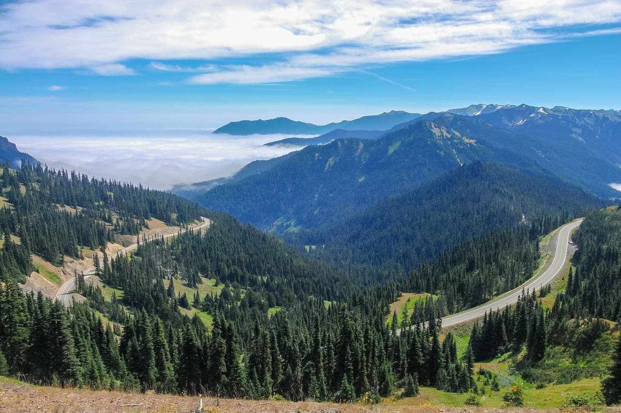
Hurricane Ridge Road is the park's one paved route into the high country — seventeen miles of switchbacks climbing from near sea level to roughly a mile high, where the forest gives way to open alpine sky. In summer it's open daily but can close anytime for snow or a full parking lot, so arrive early. In winter it's plowed Fridays through Sundays only, and tire chains are required. There is no drinking water at the summit, so fill your bottles before you start the climb.
Take the turn here at Heart o' the Hills, because this is the one. Of all the roads on the peninsula, this is the only one that carries you up into the wilderness that most people ever only see from far below, hazy on the horizon. Seventeen miles of switchbacks ahead, climbing from near sea level toward a full mile high. Settle in and watch what happens to the world as you climb. The forest closes in tight at the bottom — big dark firs, mossy and damp — and the air's still warm and close. Then your ears start to pop, the temperature slides cooler degree by degree, and mile by mile the trees themselves start to shrink. They thin out, they get scrappier, wind-bent, and then all at once the whole world cracks open and there's sky everywhere. That's the gift of this drive — you climb right out of the forest and into the air. Now let me be straight with you about the road, because it's a real mountain road and it has rules. In summer it's open every day, but it can shut on a moment's notice — for snow even in June, or simply because the lot at the top has filled up. So come early; midday on a sunny weekend, you may sit and wait. In winter it's plowed only Friday through Sunday, and every vehicle has to carry tire chains, no exceptions. And here's the one nobody remembers until it's too late: there is no water at the top. None. So fill your bottles now, while you're thinking about it. Do that, take the climb slow, and let it build. What's waiting up top is worth every switchback.
Photo: Cody Logan (Clpo13) · CC BY-SA 4.0
Hurricane Ridge Road is the spectacular paved climb that carries you from sea level in Port Angeles to subalpine country in just 17 miles. The roughly 45-minute drive gains over 5,000 feet, threading through three tunnels and past pullouts where the Strait of Juan de Fuca, Canada's Vancouver Island, and rank after rank of forested ridgelines drop away below you. It is one of the few roads in Olympic National Park that delivers you straight into the high country.
The route passes the Heart O' the Hills entrance station before switchbacking up the mountainside, with the temperature often dropping noticeably as you ascend. Roadside viewpoints reward unhurried drivers, and on clear days the panorama opens to the interior Olympics and Mount Olympus. Because the road climbs so steeply and so quickly, weather at the top can differ sharply from the coast, so conditions at the summit are worth checking before you set out.
- • The road climbs 17 miles from Port Angeles to the ridge, about a 45-minute drive; start at the Heart O' the Hills entrance station.
- • A $30-per-vehicle, 7-day Olympic National Park pass is required and is collected at the entrance station.
- • In winter the road is plowed and open only Friday through Sunday (plus a few holidays), with uphill access 9 a.m. to 4 p.m. and all vehicles required to carry tire chains.
- • Temporary closures can occur anytime due to snow or when the summit parking lot fills, so check current conditions before the climb.
- • Real-time road status is available at the park's road-conditions page or by phone at (360) 565-3131; fuel up before the climb.